NATURAL DISASTERS
VOLCANO ERUPTION


-Mayon Volcano, active volcano, southeastern Luzon, Philippines, dominating the city of Legaspi. Called the world’s most perfect volcanic cone because of the symmetry of its shape, it has a base 80 miles (130 km) in circumference and rises to 8,077 feet (2,462 metres) from the shores of Albay Gulf.
-Popular with climbers and campers, the volcano is the centre of Mayon Volcano National Park (21 square miles [55 square km]). There are large abaca plantations on its lower slopes. There have been more than 30 eruptions recorded since 1616. An eruption in 1993 caused 79 deaths. Subsequent eruptions in 2000, 2006, 2009, 2014, and 2018 forced tens of thousands of people in nearby villages to evacuate. In December 2006, rains from powerful Typhoon Durian caused mudslides and floods at the foot of the volcano that killed more than 1,000 people. Its most destructive eruption was in 1814, when the town of Cagsawa was buried and approximately 1,200 people were killed.
-On 16 January, the provincial board declared Albay under state of calamity, allowing local governments to use their calamity funds for relief operation. An 8-kilometre extended danger zone was implemented when the alert raised to level IV. Families within the radius were ordered to evacuate and seize activities.
-NDRRMC reported on the total number of volcanic earthquakes and rockfall events. The DSWD-Disaster Response Operations Monitoring and Information Center (DROMIC) reported that a total of 23,786 families or 91,055 persons in 61 barangays in Albay were affected by the phreatomagmatic eruption of Mayon Volcano. On 29 March, the alert level status of the volcano was downgraded to Level II, allowing families to return to their homes.
Summary of response
PRC complemented the efforts and assistance provided by the Government to the affected population.Key activities include the implementation of education, health and first-aid, livelihoods through the injection of multi-purpose cash programming approach, shelter support through non-food item (NFI) distribution, water, sanitation and hygiene (WASH), and welfare and psychosocial support (PSS). PRC’s planned target against actual reached is in Table 1. Based on the overall target, PRC was able to reach 97 per cent of its target. The programme was able to support 22 per cent of the total affected population.
TYPHOON YOLANDA

-LEGAZPI CITY–Philippines braces for supertyphoon Yolanda (international name: Haiyan), dubbed as one of the “most intense if not the strongest”, as it enters the country early Thursday and make its landfall in Eastern Visayas by Friday.
-Yolanda is the 24th typhoon to hit the country this year. As of this writing, 13 areas in the Visayas and Mindanao have been placed under storm signal number 1.
-Placed on red alert were Metro Manila and the regions of Calabarzon, Mimaropa, Bicol, Western Visayas, Central Visayas, Eastern Visayas, Caraga and Northern Mindanao, said NDRRMC spokesperson Major Rey Balido.
-Meanwhile, millions of volcanic debris deposited over the slopes of Mt. Bulusan in Sorsogon and Mayon volcano in Albay is posing extreme danger to residents living in low flying areas, Alex Baloloy of Phivolcs warned disaster officials and responders in RDRRMC meeting here.
-Baloloy said that 30 villages from five towns of Albay such as Guinobatan; Camalig; Daraga; Sto. Domingo; Bacacay and the tree cities of Legazpi; Ligao; and Tabaco are at risk from lahar flow as millions of volcanic materials might be remobilized with extreme rainfall associated by TS Yolanda.
-Extreme rainfall may trigger landslides and excessive erosion of old pyroclastic deposits in the upper slopes of Mayon volcano, generating lahar in all river drainages. Potentially large magnitude lahars can threaten downstream communities all river channels with inundation burial and washout,” Phivolcs official said.
-Baloloy said that in Guinobatan town, the barangays susceptible to lahar flows were Masarawag, Maninila, Maipon, Tandarora and San Rafael; Tumpa, Soa, Maninila, Quirangay, Salugan, Libod in Camalig; Busay, Binitayan, Tagas and Kilicao in Daraga; Lidong, San Isidro, San Antonio in Sto. Domingo town; Binitayan in Malilipot; Hindi in Bacacay; San Vicente in Tabaco City; Nabunton and Nasisi in Ligao City; Mabinit, Bonga, Pawa, Buyuan, Padang and Bigaa in Legazpi City.
-While in Sorsogon province, Phivolcs said that extreme rainfall may case excessive erosion of existing pyroclastic deposits in the upper slopes of Bulusan volcano, triggering lahars in rivers draining the southeastern, southwestern and northwestern flanks. Potential moderate-volume lahars can threaten downstream communities along the Malunoy Patag, Mapaso, Cada-an, Tinampo and Cogon rivers in Irosin and the Anog-Rangas River in Juban.
-Due to this, Phivolcs recommended a pre-emptive evacuation of communities in pre-determined zones of high lahar hazards in Mayon and Bulusan volcanoes for the duration of the passage of super typhoon Yolanda.
-To attain zero casualty goal of the government, the provincial government of Albay led by governor Joey Salceda said that hundreds of thousands people will be evacuated tomorrow in its pre-emptive evacuation measures.
-Based on Albay PDRRMC statistical database and estimates of impacts, Tropical Storm “Yolanda” is likely to affect 134,248 families or 665,433 persons.
The largest risk group is composed of houses made of light materials prone to wind hazard, with 46,335 families, he said. Second are households in low-lying areas and riverbanks at risk to flood hazards, with 34,453 families.
-The third group refers to households near lahar deposits – mainly Daraga, Legazpi City, Guinobatan and Camalig- and are at risk to lahar flows, with 22,622 families.
-Belonging to the fourth group are households living in coastal barangays that are at risk to storm surge, with 16,292 families. The fifth group includes households living in mountain slopes and are at risk to landslides, involving 14,546 families.
-Salceda said 165 barangays are prone to landslides while 67 barangays could be affected by mudflows or lahar flows.
-A total of 484 barangays in Albay, involving 299,396 individuals living in flood-prone areas, could be possibly affected by floods.
-Bernardo Rafaelito “Raffy” Alejandro, OCD director and RDRRMC chairman in Bicol said that for landslides 98,339 families or 498,331 people will be evacuated for zero casualty goals.
-Camarines Norte has the higest number of population to be evacuated with 24,668 families or 123,340 persons; followed by Albay with 21,080 families or 105,396 persons; Catanduanes 20,432 families or 102,156 people; Camarines Sur, 14,123 families or 77,260 persons; Sorsogon with 13, 156 families or 65, 778 persons and Masbate with 4,880 families or 24,401 persons or a total of 98,339 families or 498,331 people.
-For floods, Alejandro said 232,197 families or 1,163,496 people will be evacuated in high grounds. Camarines Sur has the highest population with 146,697 families or 735,995 people; followed by Albay 43,723 families or 218,619 persons, Camarines Norte, 22,699 families or 113,493 people, Catanduanes, 8,131 families or 40,653 persons; Sorsogon with 6,067 families or 30,335 people and Masbate province with 4,880 families or 24, 401 people.
-For floods and landslides Alejandro said during the RDRRMC meeting held at APSEMO provincial disaster operation center that disaster responders will be evacuating 330,536 families or 1,661,827 people across the Bicol region starting today.
MAGNITUDE 6.6 EARTHQUAKE

-A magnitude 6.6 earthquake rocked the Bicol region on Tuesday morning, August 18.
-According to the Philippine Institute of Volcanology and Seismology (Phivolcs), the earthquake struck at 8:03 am, west of Cataingan, Masbate. It was tectonic in origin, at a depth of 1 kilometer.
-The Phivolcs bulletin added aftershocks and damage were expected.
-"There are a lot of damaged houses," said Staff Sergeant Antonio Clemente in Cataingan, a town on the impoverished Masbate Island several kilometers west of the epicenter in the Samar Sea.
-"It was really strong."
-Local radio station reporter Christopher Decamon said he saw emergency workers pull the body of a man from the rubble of a 3-story house on the outskirts of Cataingan. The man's wife escaped unharmed.
-Police confirmed the man's death. So far there have no other reports of casualties but search and rescue efforts are still underway.
Damaged property
Homes in poor rural areas of the Philippines are often made from lightweight material such as wood.
The quake struck as the archipelago battles surging numbers of coronavirus cases, with restrictions on movement that vary across the country.
In nearby Palanas town, police chief Captain Alvin Guerina told the Agence France-Presse (AFP) that several patients, including a pregnant woman about to go into labor, were evacuated from a hospital as a precaution in case of aftershocks.
JIAN DOLOSA- TROOP RESEARCHER (REGION V)
Magandang Araw!
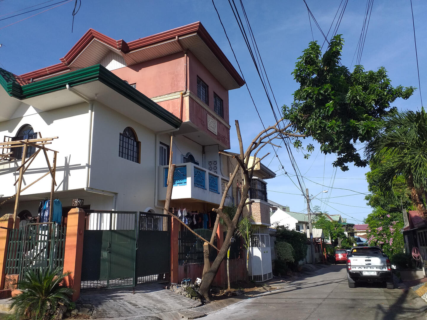
Welcome to Angono

-Located 30 kilometres (19 mi) east of Manila, and with the continuous expansion of the metropolis, it is now considered part of Metro Manila's conurbation.
-The Name "Angono" was derived from the myth of Panguno which Comes from the word "Ang-uno" which means "The Dwarf".
-It is best known as the "Art Capital of the Philippines", being the hometown of national artist for music Lucio San Pedro and national artist for visual arts Carlos "Botong" Francisco,as well as the site of the Angono Petroglyphs, the oldest known work of art in the Philippines. It is currently campaigning for its inclusion in the UNESCO Creative Cities Network as it is a center for visual arts. It is also campaigning for the inclusion of the Angono Petroglyphs (1 of 5 properties of the Petroglyphs and Petrographs of the Philippines UNESCO tentative site) in the World Heritage List.
-First created as a pueblo in 1766, Angono was a barrio of its neighboring town Taytay and Binangonan before it was legally proclaimed an independent municipality in 1938 by then President Manuel L. Quezon.
TYPHOON ONDOY
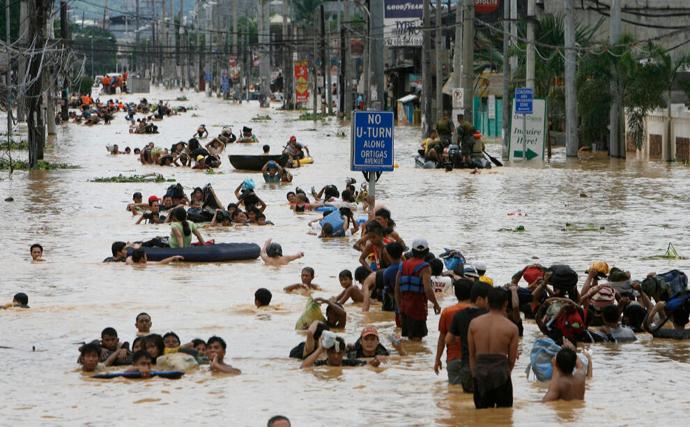
-Typhoon Ketsana, known in the Philippines as Tropical Storm Ondoy, was the second-most devastating tropical cyclone of the 2009 Pacific typhoon season, causing $1.09 billion in damages and 747 fatalities, only behind Morakot earlier in the season, which caused 789 deaths and damages worth $6.2 billion. Ketsana was the sixteenth tropical storm, and the eighth typhoon of the season. It was the most devastating typhoon to hit Manila,surpassing Typhoon Patsy (Yoling) in 1970.Ketsana formed early about 860 km (530 mi) to the northwest of Palau on September 23, 2009. The depression remained weak and was downgraded to a low pressure area later that day by the Japan Meteorological Agency (JMA) and after drifting through extremely favorable conditions, it intensified the next day and was categorized as Tropical Depression by the Philippine Atmospheric, Geophysical and Astronomical Services Administration (PAGASA) and was given the name Ondoy after entering the Philippine Area of Responsibility. The Joint Typhoon Warning Center (JTWC) issued a Tropical Cyclone Formation Alert on the depression. It was then upgraded to a tropical depression by the JMA later that morning before the JTWC followed suit early on September 25, designating the depression as 17W. Soon, Ketsana was upgraded to a tropical storm before passing over the Philippines. As it moved into the South China Sea the storm intensified while moving toward the west, and was categorized as a Severe Tropical Storm by the JMA.
TYHPHOON LOLENG
-Typhoon Babs was a powerful typhoon that struck the Philippines (where it was locally known as Typhoon Loleng) just days after Typhoon Zeb hit the same area. The seventh typhoon of the 1998 season, Babs formed on October 14 between the Philippines and Guam. The storm moved westward initially, failing to intensify initially due to the outflow from Typhoon Zeb to the northwest. Babs slowed and briefly turned to the south before advancing to the northwest, whereupon it rapidly intensified into a strong typhoon. On October 20, the official Japan Meteorological Agency (JMA) estimated peak 10 minute winds of 155 km/h (100 mph), while the unofficial Joint Typhoon Warning Center (JTWC) estimated peak 1 minute winds of 250 km/h (155 mph), making Babs an unofficial super typhoon. The storm struck the Philippine island of Catanduanes at that intensity and weakened slightly before hitting Luzon. Babs turned northward once in the South China Sea, later weakening due to unfavorable conditions and transitioning into an extratropical cyclone on October 27 in the Taiwan Strait.
LAHAR- TAAL VOLCANO
-The eruption of Taal Volcano in Batangas, Philippines on January 12, 2020, was a phreatomagmatic eruption from its main crater that spewed ashes across Calabarzon, Metro Manila, and some parts of Central Luzon and Ilocos Region, resulting in the suspension of school classes, work schedules, and flights in the area.The Philippine Institute of Volcanology and Seismology (PHIVOLCS) subsequently issued an Alert Level 4, indicating "that a hazardous explosive eruption is possible within hours to days.
JOSEPH BACAL-TROOP RESEARCHER (Angono)
SUMMARY REPORT

Above are all valid information researched by the corresponding Troop Researchers
Jian Dolosa- Group Designer and Collector

HAZARD MAP
-It indicates settlement areas that are at risk from floods, avalanches, landslides and rockfall. A separate map exists for each of these hazard categories. The maps can be used to identify areas that could be flooded by the next storm, locations where avalanches could be released and slopes where a landslide could arise.
-The hazard maps also provide detailed information about the causes, course, spatial scope, intensity and probability of occurrence of natural hazard events.
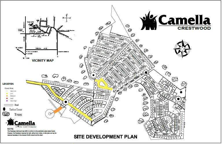
Crestwood
Barangay San Luis, Antipolo City
-A blooming lifestyle in Antipolo City Relish the fresh lifestyle in Camella Crestwood, Antipolo. With the elevated topography of Antipolo, it allows you to have a splendid view of the metropolitan skyline and evening lights. A Spanish Mediterranean-inspired community, Camella Crestwood lets you experience a truly relaxing experience of home living
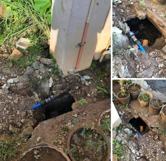
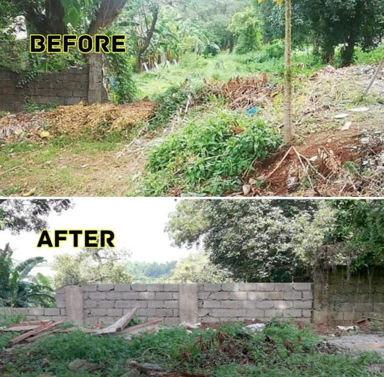
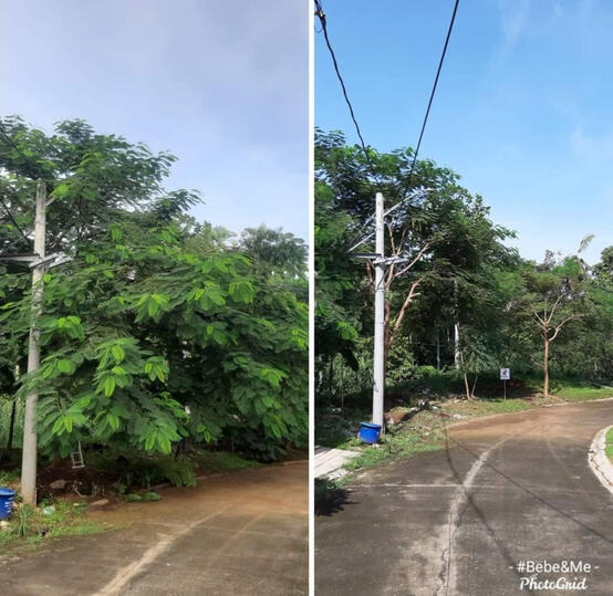
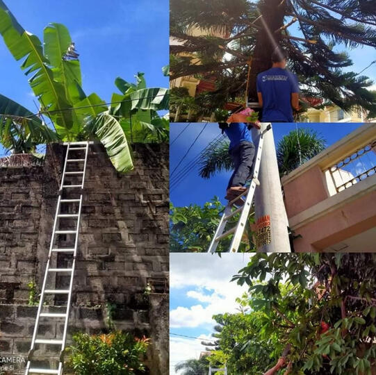
VILLAGE PICTURES
Problems and Disasters

"LEADERSHIP"
An Interview Article

-Mr. Rogie Ylagan is our guest for our short interview in ED-LOCATIONS (Map Hazards) and our topic is Identifying the Areas or Location that is exposed to Hazard in Barangay San Luis especially In Crestwood.
-Our group prepared some questionnaires that Mr. Ylagan will answer.
-So let's introduce and give him a short background, Mr. Rogie Ylagan is a member of the Board of Directors in Homeowners association in their subdivision. He and his Family lives in San Luis for about 10 years and it still counts. He is also currently the Vice President of Homeowners Association in Barangay San Luis and this is his first Term of service. He is currently working in Sun life Financial as an Advisor and Manager as well.
The Questions asked and his answer:
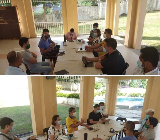
As one of the leaders, How were you able to lead the people when disaster struck?
“Hindi niya masasabing may disaster sa subdivision naming, but of course malaking disaster itong pandemya pero hopefully wala na, pero ang ginagawa namin una syempre is “PREVENTION & AWARENESS” like katulad may nagreport sa Fb page naming na may crack daw ang tulay so nagpost yung nagreport so pinuntahan naming, imagine kong walang pakialam ang mga kapitbahay so walang mangyayari, sa mga ganong bagay pinaghahandaan talaga naming.”
Papaano kayo nakakacope up within this pandemic?
“Nakakatuwa lang kasi kong ano ang tradition naming noon or mga nakasanayan naming gawin na event like Christmas party or hallowen party ginagawa na naming talaga yun yung wala pang pandemic pero hanggang ngayon ginagawa pa din naming through Fb pages contest like ganon pinagpatuloy namin dahil sa mental health ng mga tao kaya kaming mga Officers sabi namin”Hindi pwedeng mawala kong ano ang nakasanayan ng mga tao.”’
and syempre namigay kami ng Food packs sa mga na nga-ngalangan na tao atleast nakatulong kami sa aming subdivision.”
How were you able to plan out the Quarantine protocol in your Subdivision.?
“Actually ang hirap yung quarantine protocols ng government so nagmeeting kami like sa zoom meeting every time na nagpopost kami sa guard house alam na ng aming mga kapit bahay or di kaya sa Fb Groups updated lahat ng mga tao namin dito.”
Ano-ano ang mga ginagawa niyong paghahanda ng nagsimula o diniklara ni Pangulong Duterte?Paano ito naka-apekto sa pangaraw-araw niyong buhay.?
“First is transportations ayon ang pinaka malaking impact saamin,syempre bawal lumabas ,bawal bumili and curfew. Sa laki din ng subdivision namin isa sa major project namin is nag Hire kami ng isang tricycle lang na pwedng magdeliver na door to door sa subdivision dito and pinagbawalan din naming magpapasok ng outsider sa subdivision at don lang talaga sa gate, and of course ma-maintain namin ang Safety ng mga tao sa Subdivision namin.”
He said that the struggle he experienced is the lack of communication because every household has a different number of people, different beliefs, different background and different stances in life.
“Naniniwala ako na ang pinakaimportante sa leadership ng isang, Any organization needs communication”
“Hindi ako naniniwala masyado sa more on parusa talagang sakin mas magandang mai-relay mo yung importance kung bakit, more on information/dissemination na sabihin mo sa kanila bakit hindi sila pwedeng lumabas.”
“Malaking bagay talaga na nagfocus kami sa communications kasi very few” he’s talking about the people who are not going outside.
“In a way ayoko rin naman ng masyadong nananakot pero tingin ko yung pagbibigay ng information nagkaroon din nung fear.”“Prevention is better kesa sa magparusa”“I think yung leader wala naman sa position yan eh.”“Yung pagiging leader nga it’s more of an influenced e, and tingin ko rin yun yung reason kaya naman ako binoto nung iba kasi yung influence ko even before na tumakbo ako nandon na.”“Being a leader does not mean anything it only means that we should provide a good example for the leaders of tomorrow.”
PICTURES ABOVE ARE ALL FROM Mr. ROGIE YLAGAN
CRESTWOOD Geohazard map was created by the rightful owners of it but the one who modified it is Grayle Gayagay
INTERVIEW ARTICLE - Kate Arenza, JM Ticsay, and Loanne Ruallo
The one who modified this whole page - Jian Dolosa
Robinsons Homes
Barangay San Jose, Antipolo City
Live where you work and love where you live at Robinsons Homes East, a sprawling Mediterranean-style subdivision nestled in the rolling hills of Antipolo. This Mediterranean Eden located high up in Antipolo provides the cool atmosphere, lush green surroundings, and friendly neighborhood that every family and homeowner wants. Set up shop in its active commercial arcade, with sports facilities and a children’s playground, ideal for both a growing family and a growing business. Address: E. Rodriguez Avenue, Antipolo City, 1870 Rizal
VILLAGE PICTURES
UNRESOLVED PROBLEMS


THE PICTURES ABOVE ARE ALL FROM JIAN DOLOSA
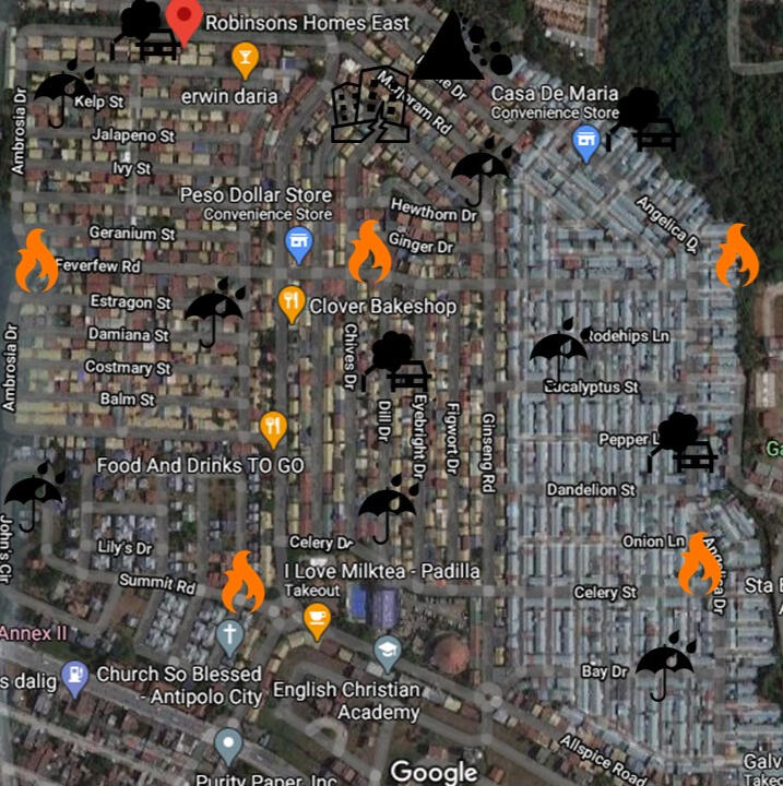
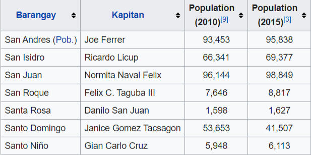
Cainta and Angono
Province of Rizal ( Region IV-A )
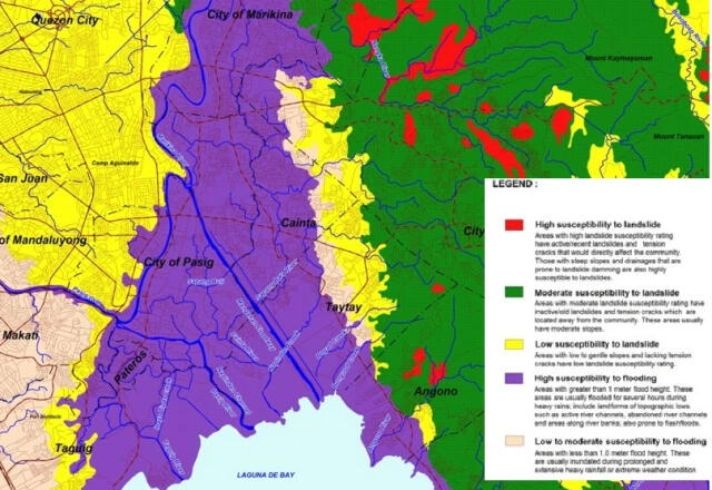
This is an another graph of Cainta, Rizal which represents different kinds of calamities which is also represented by colors
Purple - Susceptibility to flooding
Yellow - Low Susceptibility to landslide
Green - Moderate to landslide
-
There are 3 types of Colors represented in the graph and each color represents how prone the area to certain calamities
Yellow = LowOrange = MediumRed = High
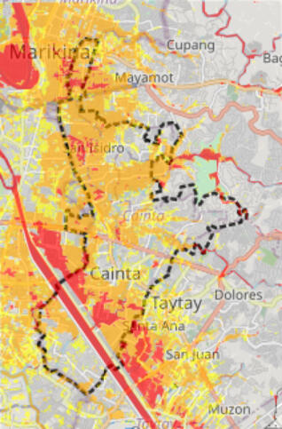
(For the table above)
-In the Geohazard map you can see that the Barangay San isidro is the largest barangay and affected by the flood moderately by the flood by the orange color with a little bit of red which makes it dangerous. The next one is San Juan which is highly affected by the flood because of the river beside it and in as you can see at the graph there is a lot of red areas in the Barangay San Juan which makes it very dangerous among the 7 barangays and same for the Barangay San Andres which there is a river beside it and a lot of red areas in the graph which makes it dangerous for people to live because of high probability of flooding depending on the weather and the rest of the barangays are less prone to calamities like flooding because the graph represents that there are a lot of places without colors that makes it safe to flooding but not in different kind of calamities
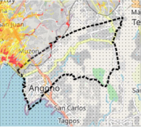
(For ANGONO MAP)
Based from the hazard map above, I can say that Angono,Rizal is not prone to flood.Angono, Rizal 5 Year Flood Hazard MapThis shapefile, with a resolution of 10 meters, illustrates the inundation extents in the area if the actual amount of rain exceeds that of a 5 year-rain return period.Note: There is a 1/5 (20%) probability of a flood with 5 year return period occurring in a single year. The Rainfall Intesity Duration Frequency is 243.100mm. 3 levels of hazard: Low Hazard (YELLOW) Height: 0.1m-0.5m, Medium Hazard (ORANGE)Height: 0.5m-1.5mHigh Hazard (RED)
Klonky Reyes and Andrei Lama - Cainta map and informations
Joseph Gabrielle Bacal- Angono map and informations